Booking
Cartographie Facebook Instagram Mail

Coming to The PAarc

By public transport

  • The nearest stop to the PAarc is Gare de Gravelines, served by DK Bus line 22. Find the HOURS and the PLAN of the line by clicking on the links.
  • From the Gravelines Train Station stop, it's a 15-minute walk to the PAarc, following the map below. Once you're in Rue du Guindal, take the "Pont des Jésuites" path on the left. This will save you crossing the dual carriageway, which is dangerous for pedestrians 🙂

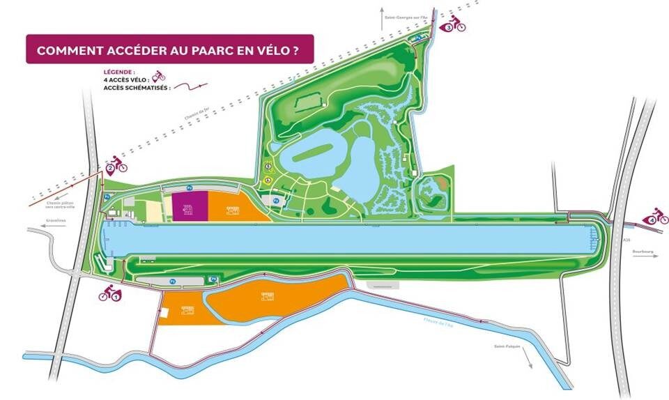
Bike access from the four's cardinal points :

The PAarc is accessible by bike through four entrances, each connected to secure routes:

  • North: From Gravelines, along the Aa Canal, with direct access to the water sports center.
  • East: From Bourbourg, via a marked path leading to the nature area and wetlands.
  • South: Through greenways and rural roads connecting the southern districts of Gravelines.
  • West: From departmental roads and cycle paths serving sports and leisure areas.

The PAarc des Rives de l’Aa is fully committed to promoting soft mobility and sustainable development. The "Bike Welcome" certification comes with a range of services and information for cyclists: dedicated signage, access maps, tourist information, and water points…
By car

FROM LILLE AND DUNKIRK

  • Motorway A 25, follow Calais, then motorway A 16 exit 52 b (Bourbourg / Gravelines)
  • At the exit, head towards Gravelines and continue on the D11 (for 4.3 km)
  • At the roundabout, turn left towards PAarc des Rives de l'Aa on the D601 (1.6 km)
  • On the left is the PAarc des Rives de l'Aa - Turn left to get there.

FROM CALAIS

  • Motorway A 26, follow Dunkerque then motorway A 16 exit 52 (Bourbourg / Gravelines)
  • At the stop sign at exit 52, turn left towards Gravelines and continue on the D11 for 4.3 km.
  • At the roundabout, turn left towards PAarc des Rives de l'Aa on the D601 (1.6 km)
  • On the left is the PAarc des Rives de l'Aa - Turn left to get there.